Sherbrooke Forest is an area of 802 hectares and contains three vegetation types; Wet Forest, Damp Forest and Cool Temperate Rainforest. It is surrounded by residential properties, except for part of the eastern edge which borders on farmland.
It contains the stand of Mountain Ash (Eucalyptus regnans) nearest to the city of Melbourne, and is a popular tourist destination. One of its greatest attractions is the Superb Lyrebird which are easily heard and observed along the main walking tracks.
Sherbrooke Forest became part of the newly formed Dandenong Ranges National Park in 1987. It was formerly managed by the Forests Commission as a State forest – until 1983. Since 1996, Parks Victoria has managed Sherbrooke Forest as part of the National Park under the auspices of the Department of Environment, Land, Water and Planning. A volunteer group, the Friends of Sherbrooke Forest, was formed in 1980 and remains an active group more than forty years later.

Fire, pines and their aftermath
There has not been a major wildfire in the forest since February 1923, when seventy-two percent of the forest was burnt. A small area on the eastern side was burnt in the 1926 wildfire. There was also a fire on Coles Ridge in 1946, which resulted in establishment of a plantation of Monterey Pines (Pinus radiata) by local schools. There was no attempt to regenerate the Mountain Ash. Other areas planted with pines were the O’Donohue Memorial Plantation, the Melbourne High School Plantation and the Sherbrooke Plantation on Ridge Track which was clear-felled in 1977 and replanted with Mountain Ash that year.
The authorities did not act to remove English Ivy in the area of the Sherbrooke Plantation from 1977 and as a result of the disturbance, English Ivy was able to establish and completely overwhelm the lower storey native vegetation, as well as climbing to great heights up the Mountain Ash. The Mountain Ash were only about ten years old when the Friends started removing English Ivy there by hand. This also occurred in other areas where timber was removed from the forest from 1904 until 1927.
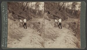
In 1985, the Schools Plantation on Coles Ridge Track was removed over three years. Before any felling commenced the English Ivy vines were cut from the trees and the ground ivy was treated with herbicide. This approach was continued when the two remaining pine plantations were removed over the next two years. The slash was burnt and the areas were hand sown with Mountain Ash seed collected from trees within the forest. Thousands of pine seedlings that germinated were hand weeded by the Friends group over the next few years. The photos linked here tell the story.
The same process was used when the two remaining pine plantations were clear-felled, although the Melbourne High School Plantation required supplementary planting due to its shaded location.
Weed control
The Friends group successfully hand-weeded English Ivy from the areas where the pines were removed in the 1970s, as well as an area on the eastern side of the forest where timber was removed from 1904 to 1927. The latter area also needed herbicide control as the soil was mainly clay, making hand-weeding almost impossible, as opposed to the rich mountain loam on the western side of the forest.
Both the areas of forest where English Ivy was the dominant ground cover were not used by lyrebirds, as the dense foliage made contact with the soil impossible. Once the ivy was removed the lyrebirds returned and display mounds were discovered almost immediately. The lyrebirds even used the piles of dead ivy as a source of invertebrates for food, as well as nest construction. The area of ‘dead’ forest was brought to life.
The Friends group commenced a systematic survey of the forest’s vegetation in 1984 to determine areas of environmental weeds within the forest. Unfortunately, the result of this survey revealed that the forest was in a deplorable state. The main weeds found were English Ivy (Hedera helix), Sweet Pittosporum (Pittosporum undulatum), English Holly (Ilex aquifolium), Red Cestrum (Cestrum elegans) and Sycamore Maple (Acer pseudoplatanus). All of these species were introduced to the Dandenongs via plant nurseries in the early 1900s. The first four species produce a berry-fruit which is eaten by birds. Sycamore Maple has a winged-seed that can be carried many miles into the forest. No weed control except for Blackberry (Rubus fruticosus), Angled Onion (Allium triquetrum) and Red Cestrum (Cestrum elegans) had been carried out in the forest for at least forty years.
While environmental weeds such Sweet Pittosporum and English Holly were not recognised as a threat to the indigenous vegetation, the increasing abundance of English Ivy was taking over valuable lyrebird feeding areas. By the time the Friends started work this plant had covered many hectares of ground on both sides of the forest.
Over the next thirty years the Friends systematically poisoned these woody weeds using the drill and fill method. The herbicide used was full-strength glyphosate. Smaller plants of Red Cestrum were removed using a mattock, although some bushes were so large that they were poisoned. The group now carries out follow-up weeding throughout the forest.
Future prospects for weed control
A forest surrounded by residential properties in which environmental weeds are grown will forever have the problem of seeding by birds. Although the local council provides information with regard to these weeds, many residents resist removing them from their gardens.
From survey maps it is possible to see the correlation of weed invasion with proximity to residential gardens. See maps of Sycamore Maple and Cestrum; and of Sweet Pittosporum and English Holly. These weed distribution survey maps are from 1984 (when the survey commenced) to 2001 (when it finished). The group surveyed every second Sunday of every second month over this time. (It always prioritised weed control). Maps also show the abundance of English Ivy in areas disturbed by the planting of Monterey Pine and timber felling: see maps linked here.
Lyrebirds
In 1983, lyrebird numbers were dramatically reduced when eleven birds were killed within a few months. Predation by foxes, wandering domestic dogs and cats were thought to be the cause. Although there was a general outcry by the public, it was not until 1988 that the local council and the then Department of Conservation, Forests and Lands set up a working group to give advice on ways to halt this decline.
Recommendations by the Advisory Committee included registration of cats, a dusk to dawn curfew for cats, and the limiting of two cats and two dogs per property. Altogether, five drafts were submitted to the Council over four years. In June 1991, the Animal Welfare Local Law was finally passed. Although controversial at the time, the law was accepted by most residents. Parks Victoria also instigated a program to poison foxes. Since then, the lyrebird population has stabilised and wallaby numbers in the forest have increased. The Sherbrooke Lyrebird Survey Group monitors lyrebirds throughout the year, as well as holding three dawn surveys during June and July. Young lyrebird chicks are banded while in the nest, so the group can track where they move as adult birds.
The Friends of Sherbrooke Forest and management authorities
This group was formed under the Forests Commission of Victoria in 1980. Work parties were held once a month in areas suggested by the Ranger-in-charge. The group quickly developed a good working relationship with the staff. Once trust had developed on both sides, the group was given permission to work in areas that had been discovered during the Friends vegetation surveys. A ranger always put in an appearance at these work parties and worked alongside the group.
When the Forests Commission of Victoria was dissolved in 1983, the Forester-in Charge at Kallista remained in his position, retiring in 1985. The superseding agency was the Department of Conservation Forests and Lands. The Friends continued to have a good relationship with the new staff. One constant throughout the Friends volunteer work in the forest was the continued presence of the Head Ranger. This individual had started work with the Forests Commission when he was fifteen years old. His final position was Head Ranger of the Dandenong Ranges National Park, until he retired at fifty-five years of age. He now is a regular volunteer with the Friends.
Sambar Deer
In 1996, a member of the Sherbrooke Lyrebird Survey Group came face to face with a large Sambar Deer. This was the first actual sighting, though some Friends had wondered what was browsing the lower branches of English Holly in the eastern side of the forest. As their numbers increased, the damage they caused to the native vegetation became more evident. The impacts of deer include long term changes to vegetation and plant communities, such as:
(a) Browsing of ground ferns along creek corridors causing:
- compaction of soil on frequently used tracks
- erosion along creek banks
- silting and sedimentation in creeks.
(b) Pruning of lower understorey shrubs such as the native Coprosma quadrifida almost to the ground by deer, resulting in an unnaturally open forest. This means that lyrebirds are more exposed to predators such as foxes and feral cats.
(c) Trampling of indigenous vegetation resulting in poor regeneration of native species.
(d) Fouling of water in creeks by deer faeces, possibly introducing viruses that deer are known to carry and creating bogs where they wallow.
(e) Competing with wallabies and wombats for food.
(f) Antler rubbing on Sassafras trees resulting in ring-barking and eventual death of the tree.
(g) Destruction of valuable species of vegetation. The Cool Temperate Rainforest Community within the forest is being threatened. Deer tend to follow creeks throughout the forest. Therefore, any damage to creek vegetation will inevitably see the disappearance of this plant community, already threatened in Victoria. Deer browse the fronds of tree-ferns within their reach continually, resulting in their demise.
In 2014, Parks Victoria commenced a deer control program, but used only volunteer shooters from the Sporting Shooters’ Association. After four years it was decided to cease this program as the number of deer being shot in the last year was zero. The Friends have maintained that for the program to be a success it would be necessary to contract professional deer shooters, and close the Park for a period of time until numbers had been reduced.
Conclusion
Although Sherbrooke Forest is a relatively ‘young’ forest as a result of the 1923 wildfire, the threats posed by environmental weeds escaping from residential gardens will be a continuing problem.
 A severe storm on 9 June 2021 blew over many mature Mountain Ash and Blackwood trees (Acacia melanoxylon), thus opening up the forest to more light and threatening the Sassafras trees (Atherosperma moschatum) in the Sherbrooke Creek gully. Many of the mature eucalypts would have been home for both possum and owl species.
If deer numbers are not controlled the structure of the forest will inevitably be changed, resulting in the loss of both indigenous flora and fauna.
The State Government must increase funding to improve the natural values of the forest. At present, funding has not been available to replace bridges destroyed by falling trees. Staff numbers are kept to a minimum, resulting on poor compliance of the public, who regularly walk their dogs along the forest tracks. The recent storm will cost thousands to clean up regular walking tracks, let alone to restore the damaged areas.
Like so many volunteer groups, the Friends of Sherbrooke Forest are an ageing group with the majority of active members being in their late seventies. Who will watch over this beautiful forest once they are unable to volunteer?
Further reading
The Friends of Sherbrooke Forest. 2000 & 2008. Sherbrooke Forest – its flora and history.
Friends of Sherbrooke Forest, Department of Conservation, Forests & Lands. 1989. Weeds of forests, roadsides and gardens : a field guide in colour for students, naturalists and land managers. Belgrave, Victoria.
Freshwater, Vivien. 2020. History of the Friends of Sherbrooke Forest 1980-2020. Friends of Sherbrooke Forest.