|
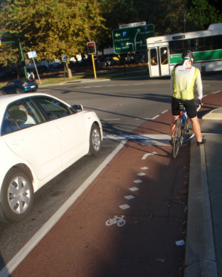
Street intersection catering for different transport modes
Source: TPG Town Planning and Urban Design
Connectivity is the directness of travel between destinations.
Intersection types and density in an area influence the directness of travel between destinations, determining how people move around, whether by foot, bike, public transport or car.
When streets are well-connected, a high proportion of the potential 400m or five-minute walking catchment to the centre is walkable.
High connectivity and good provision of walking and cycling facilities are more likely to encourage walking and cycling for transport and recreation.
How to achieve?
-
Provide a variety of local destinations within easy walking distance (400 metres is a comfortable walking distance for most people). A grid street layout with spacing of 80-100m provides an optimum network for pedestrian and vehicular needs in most circumstances.
-
Provide off-road pedestrian and cycle networks in non-grid or curvilinear street layouts.
|
Rule of Thumb
Mixed development neighbourhoods should cover a 400m radius, equating to about five minutes walk.
|
Encourage
- Connected pathways, walking and cycling routes that lead to local destinations
- Routes provided along predictable paths of travel, such as to schools, recreation facilities and shops
- Well maintained non-slip surfaces for footpaths
- Gradients that enable safe and convenient use by all users
- Improved pedestrian and cyclist safety
Avoid
- Gated communities, as they deny public pedestrian and cycling access and reduce the connecitivity and permeability of the local network
- Delayed delivery of walking and cycling paths in new subdivisions, as transport choices once established can be difficult to change
Click here for more detailed information on design and planning for Connectivity.
|
Download Full Text
Connectivity.pdf
Resources
References
Pedshed
US Walk Score
Urban Design Compendium - Making the Connections
Your Development - Walkable Neighbourhoods
Related Design Principles
Active Transport
Mixed Density
Mixed Land Use
Safety and Surveillance
|
 This project was funded by the Australian Government Department of Health and Ageing.