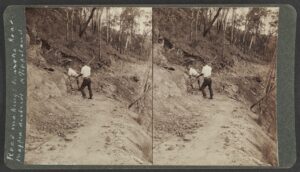
The industry and adventurism of the early scientists and naturalists investigating the colony’s “natural history” shines through this substantive official guidebook to early botanical knowledge.
Review Status: Pending

The industry and adventurism of the early scientists and naturalists investigating the colony’s “natural history” shines through this substantive official guidebook to early botanical knowledge.
This 34 page roneoed memoir has earned a place in PaRC because of the references in it to areas that are now National Park – Kulkyne, Wyperfeld-Albacutya and others.
The initials in the top right corner of the first page are of Robert Charles Anderson, an officer of the National Parks Service, joined in the late 1970s.

This small booklet was produced in 1976 by a team led by John Landy, one-time Technical Officer for the fledgling National Parks Authority and later Governor of Victoria, under the auspices of the Australian Institute of Agricultural Science (Victorian Branch).
It was launched in the rooms of the Royal Society of Victoria.
An official publication from 1961.
This rather quaint, reflective seven-page memo was written by Frank Gibbons (FR Gibbons), a soil conservationist with the Soil Conservation Authority of Victoria, housed in premises at Cotham Road Kew. “Quaint” by the standards of environmental assessment in 2025, but reflective of the times (1970).
Also, the memo offers a justification from within Christian ethics for nature conservation, respect for the earth and a modern stewardship. This is in contrast with the fundamentalist Christian position that would welcome apocalyptic collapse, a position based on the book of Revelation.
The file when originally scanned was titled “FR_Gibbons_Public_Land_Use_Guidelines_Aust_Christian_Movement_1970.pdf”. The document was apparently a manuscript for a magazine article. Anyone who knows more about the eventual outcome of the essay is invited to contact PaRC.
Frank Gibbons was a quiet, quietly spoken and unassuming officer who carries no little credit for the abandonment of the land clearing scheme in the Little Desert of 1968-1970. Among other agitation, he addressed the students in Dr EHM (Tim) Ealey’s applied ecology lectures at Monash University in 1969 and the students through the Biological Society took an active part in the campaign, including handing out leaflets in the Melbourne City Square.
Many, many individuals and groups of course contributed to a momentum of that campaign. Frank Gibbons’s contribution to orderly land-use planning was another level above quiet agitation. With his colleagues at the Soil Conservation Authority, and RG Downes its Director not least, the scientists involved in land assessment lay the groundwork for the land-use studies of the Land Conservation Council established by legislation in 1970. Therein lies a tale! For more, read Libby Robin’s book on the saga!
This page is a placeholder for accounts of trails and corridors and recreational use of them.

In the meantime, check the excellent websites Trail Hiking Australia and Rail Trails Australia. Rail Trails Australia lists 191 trails, such as The Red Gum Track, Hamilton to Coleraine, Victoria.
ABC Rural published an account of the Mary Valley Trail in Queensland in 2024.

This comprehensive guide of ~150 pages was prepared through collaboration between the authorities in Queensland and New South Wales as well as the University of Queensland. To access this authoritative material:
Open the Monitoring Visitors to Natural Areas index pdf which explains the structure of the report (and contains hotlinks to the individual subject sections, but the links have not yet been activated).
Open the Monitoring Visitors to Natural Areas assembled report, including Glossary, References and Appendices.
TABLE OF CONTENTS
List of tables iv
List of figures v
Abbreviations vi
Acknowledgements vii
Preface viii
PART 1 INTRODUCTION 1
1.1 Managing Natural Areas: Balancing Dual Responsibilities 1
1.2 Visitor Monitoring: Bridging the Gap 2
1.3 Objectives of the Manual 3
1.4 The Visitor Monitoring System 3
PART 2 GUIDELINES FOR ESTIMATING VISITOR USE 5
2.1 Introduction 5
2.2 Standardising Measurement Units 5
2.3 The Visitor Use Monitoring Process 5
2.3.1 Phase 1: Preliminary Design Considerations 5
2.3.1.1 Step 1: Clearly define the rationale for data collection 5
2.3.1.2 Step 2: Determine objectives of monitoring visitor use 7
2.3.1.3 Step 3: Familiarise yourself with the area 7
2.3.1.4 Step 4: Design a sampling plan 7
2.3.1.5 Step 5: Review alternative methods for monitoring use 10
2.3.1.6 Step 6: Select the most appropriate method(s) 15
2.3.2 Phase 2: Program Development 16
2.3.2.1 Step 7: Design a visitor use monitoring program 16
2.3.3 Phase 3: Data Analysis and Reporting 16
2.3.3.1 Step 8: Data preparation, analysis, reporting and storage 16
PART 3 GUIDELINES FOR VISITOR SURVEYS 19
3.1 Introduction 19
3.2 The Visitor Survey Process 19
3.2.1 Phase 1: Questionnaire Development 19
3.2.1.1 Step 1: Define survey objectives, resources and constraints 19
3.2.1.2 Step 2: Review methods of data collection 19
3.2.1.3 Step 3: Compare and evaluate survey modes 25
3.2.1.4 Step 4: Select the most appropriate method 29
3.2.1.5 Step 5: Determine survey questions 30
3.2.1.6 Step 6: Establish questionnaire layout and flow 39
3.2.1.7 Step 7: Evaluate the questionnaire 42
3.2.1.8 Step 8: Pre-test the questionnaire 43
3.2.2 Phase 2: Design A Sampling Strategy 44
3.2.2.1 Step 9: Determine the target population 45
3.2.2.2 Step 10: Determine the sample frame 45
3.2.2.3 Step 11: Select a sampling method 46
3.2.2.4 Step 12: Determine sample size 47
3.2.2.5 Step 13: Dealing with non-response 51
3.2.3 Phase 3: Administration of Questionnaires 53
3.2.3.1 Step 14: Scheduling the survey 53
3.2.3.2 Step 15: Select survey locations 54
3.2.3.3 Step 16: Determine staffing requirements 54
3.2.3.4 Step 17: Pre-survey preparation 56
3.2.3.5 Step 18: Distribute questionnaires 57
3.2.3.6 Step 19: Data management 59
3.2.4 Phase 4: Data Analysis and Reporting 61
3.2.4.1 Step 20: Prepare data for analysis 61
3.2.4.2 Step 21: Data entry 63
3.2.4.3 Step 22: Data analysis 64
3.2.4.4 Step 23: Report generation 67
3.2.4.5 Step 24: Data storage and retrieval 68
3.3 Survey Research: Ethical Issues 69
3.3.1 Informing Respondents 69
3.3.2 Protecting Respondents 69
3.3.3 Benefits to Respondents 70
3.3.4 Ethical Responsibilities to Interviewers 70
PART 4 CORE QUESTIONS MODULE 71
PART 5 QUESTION BANK MODULES:
STANDARD QUESTIONS 73
5.1 Visitor Characteristics Sub-module 73
5.2 Travel Characteristics Sub-module 74
5.3 Nature of the Visit Sub-module 76
5.4 Interpretation and Education Sub-module 86
5.5 Visitor Spending Sub-module 87
5.6 Visitor Satisfaction Sub-module 93
5.7 Natural Area Management Sub-module 94
PART 6 QUESTION BANK MODULES:
BEST PRACTICE QUESTIONS 95
6.1 Visitor Characteristics Sub-module 95
6.2 Travel Characteristics Sub-module 99
6.3 Nature of the Visit Sub-module 103
6.4 Interpretation and Education Sub-module 105
6.5 Visitor Spending Sub-module 106
6.6 Visitor Satisfaction Sub-module 108
REFERENCES 111
APPENDICES 115
APPENDIX I: Probability and Nonprobability Sampling Methods 116
APPENDIX II: Kondalilla National Park Visitor Survey: Format and Layout 119
APPENDIX III: Interview-administered Front End Interview Form 125
APPENDIX IV: Self-administered Front End Interview Form 127
APPENDIX V: Questionnaire Response Rate Form 129
APPENDIX VI: Reminder Letter Template for Follow-up Mailings 131
GLOSSARY 133

The Australian Protected Areas Congress 2008 was held at Twin Waters Resort, Queensland.
Read the consolidated proceedings Protected Areas in the Century of Change, ~279 pages, here. A wealth of information, from a formidable cast of knowledgeable people.
Masterclass
The Congress included a Masterclass on “Management Effectiveness Evaluation” of protected areas. The aims were to:
Participants (minus email addresses, but PaRC holds a copy)
Design and analysis issues for ME evaluations
Process guidelines for indicator selection for Protected Area Management Effectiveness Evaluations
Management Effectiveness Evaluation within State of the Parks Assessment and Reporting Systems: Draft Principles
Ridgeline, the newsletter of the Australian Research Council (ARC) linkage project titled “Building capacity for adaptive management in protected areas through improved systems for monitoring and evaluation”:
Presentations
Introductory presentation. Marc Hockings and Fiona Leverington.
Linking management effectiveness evaluations with on-ground management activities: An example from the NSW State of the Parks Program. Andrew Growcock.
Designing Reliable Management Effectiveness Assessments. Carly Cook.
Linking evaluation to the needs of managers. Chris Jacobson.
Great Parks Network Benchmarks: An analysis of membership management performance. Parks Forum.
Spatial tools for understanding performance within a landscape context. Josie Kelman.
Effectively managing management effectiveness. Peter Stathis et al.
Performance Assessments in Western Australia. Conservation Council of Western Australia.
Linking short-term and longer term evaluation. Tony Varcoe.
Discussion
Slides of the discussion – consolidated
Findings – with shorter list of participants, email addresses deleted.
Queensland will be hosting the 2032 Olympic Games. A few people with experience of parks and planning in the past 30 years have been concerned at the absence of any strategic plan for enhancing the liveability of the South East Queensland region. The advent of the Games offers an opportunity to bequeath a first-class network of parks, reserves and open space as well as enhancing Queensland’s reputation as a liveable community. ‘Liveability’ includes ensuring that new urban development is steered towards locations not unduly constrained by topography, biodiversity, scenic amenity or other planning criteria.
The liveability of Queensland’s urban settlements has been compromised by four significant policy milestones:
A new campaign called “SEQ Green Space Strategy 2032” was born in March 2026. This page accesses documentary materials relevant to the campaign.
For background materials, prior to March 2026, see Open space in SEQ 1994-2021; ROSS supplementary materials; and a chronology of 2004-2012 by the SEQ Community Alliance, as well as numerous other relevant documents in the twin PaRC collections. See also the website of the SEQ Community Alliance.
More than 25 years after the creation of a regional open space network was recommended in the SEQ 2001 Regional Plan, South East Queensland does not have a regional park system or any coordinated network of recreational open space worth the name. The narrative of what-might-have-been is a story of opportunities lost, at least three times over.
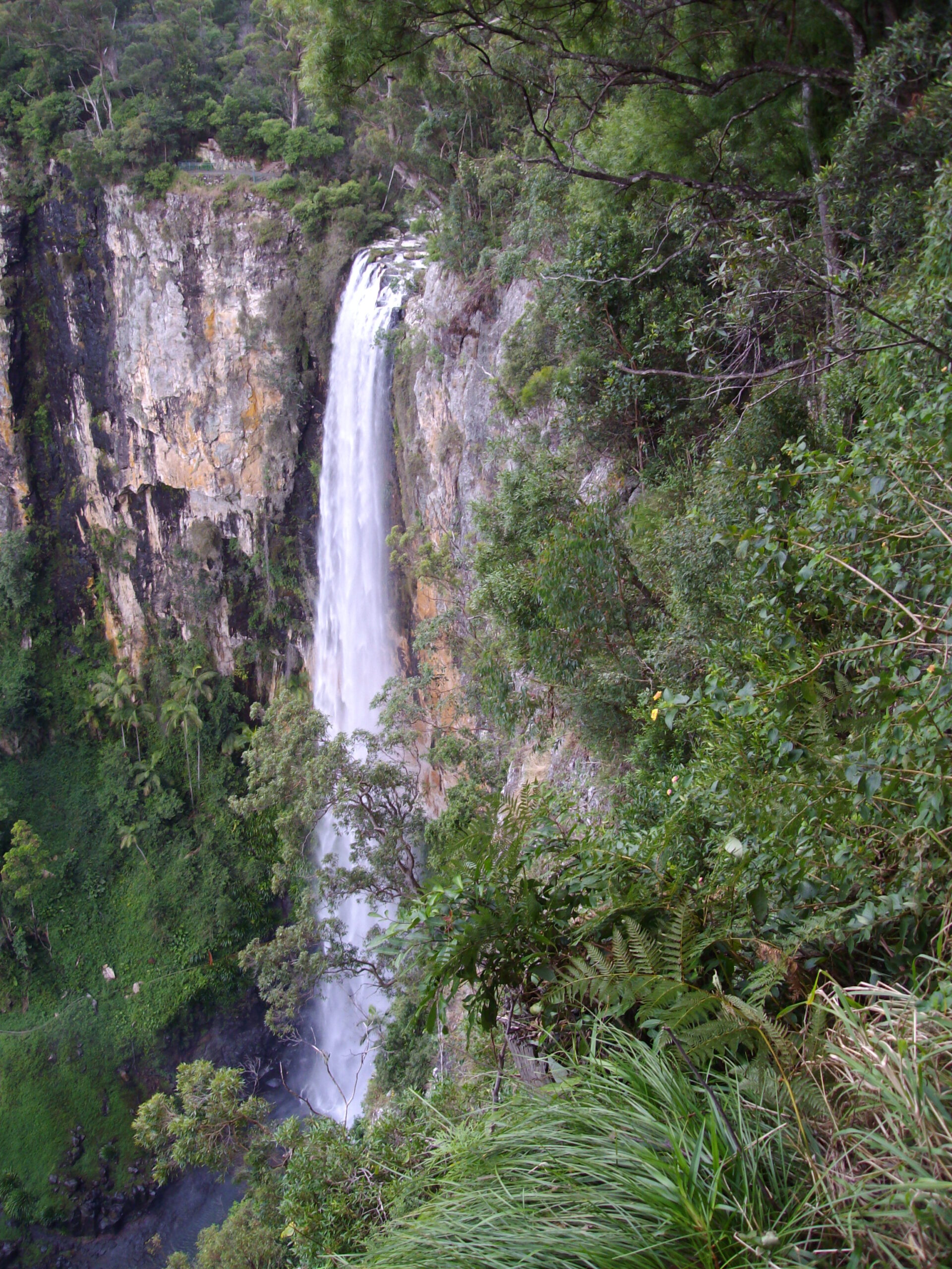 Purlingbrook Falls adjacent to the rainforest purchased under ROSS in 1994 – G. Edwards
PaRC has a general policy not to include ephemeral tourist brochures, as it is a website of record. However, exceptions can be made in some cases, particularly for the Pacific Islands which have only modest capacity to archive historical documents.
This brochure of some 28 pages offers a snapshot into the conditions of Rabaul in the late 1980s.
The file has been optimised from more than 130 MB to 3.5 MB in size. Researchers who wish to access the unreduced file should contact PaRC.
The papers of the 12th Liveable Cities Conference, held in the Adelaide Convention Centre, 12,13 August 2019. Pp.18-32. Published by the Association for Sustainability in Business Inc.
Masterman-Smith, Helen. 2019. The empowering potential of community organising in Australia: A regional city case study. https://researchoutput.csu.edu.au/en/publications/the-empowering-potential-of-community-organising-in-australia-a-r/
Abstract Building liveable cities that are just and sustainable depends heavily on the transformative potential of empowered communities. Community organising is one empowerment strategy that is resurging in many countries. Broadly speaking, it refers to the coordinated efforts of residents to collectively empower themselves to advance their socio-cultural, political, economic and environmental needs and interests. The articulation of a body of community organising theory and practice emerged from the US civil rights movement in the 1960s, especially through the work of Saul Alinksy. However, community organising has attracted limited and belated interest in Australia, most notably through the Sydney Alliance project in recent years. This case study contributes to the embryonic Australian scholarship in this field. It examines the possibilities and challenges of community organising experienced by a grassroots community building organisation based in disadvantaged neighbourhoods of the regional city of Albury-Wodonga. Interview and autoethnographic data from participants is analysed to convey the lived experience and wider implications of the under-development of community organising in Australia. The paper finds that while government and NGO support for community organising in the US and the UK, for example, have been pivotal features of prominent democratisation and community renewal initiatives, there is no similarly systematic approach to community organising across Australia as yet. This case study suggests that the neglect of community organising in Australia is sapping the appetite and capacity of many residents who wish to help build socially and ecologically just cities, independently or collaboratively with government and non-government agencies. On the other hand, the Albury-Wodonga experience indicates the significant impact that modest public investment in community organising can produce. It is contended that public investment in relevant education, skills, resources and partnerships warrants closer consideration as a possible pathway to more community-driven liveable cities.
From about 2008, a series of conferences was held under the “Making Cities Liveable” banner. The first few were also headlined “Healthy Cities”. The .com website that applied then has been taken over by a commercial entity. In about 2018, the website transferred to liveable cities.org.au, which at the date of this post appears to be broken. the Safe Cities website is also broken.
By email dated 24 August 2025, the Lennard Institute in the USA has advised PaRC that “The Australian series was not affiliated with our US-based series, which was formed in 1985 in Berkeley, California by Henry and Suzanne Lennard. We are still operating under the name “International Making Cities Livable” (hosted by the Lennard Institute for Livable Cities, an Indiana educational non-profit”.
PaRC has been able to resurrect proceedings of some of the series.
MCL Conference 2009, No. 2. Program.
MCL Conference 2010, No. 3, held in Brisbane.
MCL Conference 2011, No. 4, held at Noosa.
MCL Conference 2012, No. 5, peer-reviewed papers; Non-peer-reviewed papers. Held at Geelong.
MCL Conference 2013, No. 6, peer-reviewed papers; password ‘healthycities’; Non-peer-reviewed papers: password ‘healthycities’. Held in Melbourne.
MCL Conference 2014, No. 7. Held at Kingscliff.
MCL Conference 2015, No. 8, peer-reviewed papers; Non-peer-reviewed papers. Held in Melbourne.
MCL Conference 2016, No. 9, peer-reviewed papers; Non-peer-reviewed papers.
MCL Conference and Safe Cities Conference 2017, No. 10 Held at Brisbane.
MCL Conference and Safe Cities Conference 2018, No. 11 Held at Melbourne.
Liveable Cities Conference 2019, No. 12. Cover sheet. 2020 and Beyond – Leadership in healthy and connected global communities and regions. Held at Adelaide Convention Centre.
Liveable Cities Conference 2020, No. 13. Online.
Liveable Cities Conference 2021.

The Australian Institute of Landscape Architects (AILA) has kindly passed on its announcement of the passing of Bruce Mackenzie.
Regarded fondly as a pioneer of Landscape Architecture in Australia, Bruce Mackenzie was responsible for some of Australia’s most iconic and influential landscape projects, including the Sydney Harbour parks Illoura Reserve, Balmain and Yurulbin Reserve, Birchgrove, Sir Joseph Banks Reserve, Botany Bay and Ku-ring-gai and Glebe Bicentennial Parks.
With a career spanning over five decades, Bruce Mackenzie was commissioned to design numerous recognised Australian landmarks, winning multiple awards.
Throughout his career, Bruce was a tireless advocate for landscape architecture, a ‘calling’ that he loved and to which he dedicated his life. His passion for nature and love of the Australian landscape led to a genuinely Australian design vernacular, centred on place and context with detail consisting of natural materials and the innovative use of native plant communities. His passion, enthusiasm and generosity made him a wonderful mentor to many of today’s leading landscape architects and a familiar face at AILA led events. His welcome and consistent presence, up until he fell ill in 2023, reflected the importance of Bruce to AILA and how vital the connection was to him.
As the pioneer of landscape architecture in Australia, Bruce was loved and respected by the built environment community.
Other records of his life and work have appeared in The Sydney Morning Herald 20 January 2024, Landscape Australia and the website of the Australian Institute of Architects. See also his landmark 2011 book Design with Landscape. “Design with landscape is not only about the life’s work of a passionate Australian landscape architect, but also a textbook of how to design and build solutions to living within the landscape of the world.” (Trove).

This report, dated February 1991, commenced its life in 1990 as a study of the need for playground equipment within Redcliffe City, Brisbane northside, over the following five years. The scope of the study was extended to examine recreational facilities and programs in all parks throughout Redcliffe City (subsequently folded into Moreton Bay Regional Council).

The Brisbane Conference Statement, arising from the 2024 Parks and Leisure Australia Annual Conference, builds on the foundation from the 2023 International Congress’s Adelaide Statement. The Statement continues to pursue the six Pledges in the Adelaide Statement:
The Hobart Statement was endorsed by the November 2025 Annual Conference, with the same six themes re-endorsed. Further information is available on the website of our partner Parks and Leisure Australia.
Victoria’s national parks and other “protected areas” on public land form a world-class network of areas encompassing representative examples of many of the State’s diverse ecosystems and much of the biodiversity they contain. They safeguard many of the State’s flora and fauna species, preserve sites and features of indigenous and historical heritage, provide vital environmental services like carbon storage and water catchments, and offer nature-based recreation that supports local and regional visitor economies. They are valued as a living cultural landscape by Traditional Owners, with many now jointly managed.
“Protected area” is a clearly defined geographical space recognised, dedicated and managed through legal means to achieve the long-term conservation of nature with associated ecosystem services and cultural values (adapted from International Union for Conservation of Nature, 2008). In Victoria protected areas on public land include: national, state and wilderness parks; marine national parks and sanctuaries; conservation parks; nature conservation, nature and bushland reserves; some natural features reserves; and reference and remote & natural areas.
Despite their significance, Victoria’s public land protected areas face ongoing management and resourcing challenges. Marking the 50th anniversary of the National Parks Act (1975), a group of retired protected area managers identified the need for a professional body to offer independent advice and advocate for improved resourcing and management of Victoria’s public land protected areas. They also identified the need for a professional body to connect and represent current and former protected area management staff and facilitate opportunities for former staff to stay connected and make ongoing contributions to public land protected area management.
On 28 October 2025, the group incorporated as the Victorian Protected Areas Council Inc. and approved its Constitution and Terms of Reference. Click here for the Terms of Reference.
The purpose of the new body is “To advocate for:
“To be a professional association for Victorian public land protected area managers to:
For more information, refer to the Council’s website https://victorianprotectedareascouncil.org/.

Geoffrey Chapman, born on Kangaroo Island and a Ranger in the South Australian National Parks and Wildlife Service from 1969 until his retirement in 2001, has penned the attached 96-page history and bibliography of the early settlement of Kangaroo Island.
The fires on Kangaroo Island in 2000 destroyed the records at Flinders Chase – fortunately Geoffrey held copies. “There were rangers’ memos, various reports including details of previous fire and a smattering of history bits including the ligurian bees and Kelly Hill caves.
“My interest was due to my grandfather William aka ‘Will’ Chapman having the lease of Rocky River in 1916 to 1919 and the work ‘Will’ and his best mate ‘Bill’ Boxer did at lighthouses. I grew up listening to the stories of the two men chatting about the old days on Sunday afternoons on the homestead verandah. Reference the Cape Borda light house – there is also a ‘William Chapman’ – he was my grandfather’s ‘grandfather’ – the first Chapman to arrive on Kangaroo Island in the very early 1840s.
“When I first started writing the article, there was very little information in official park files – I obtained all of it via newspapers via Trove, my family records, personal chats with the second ranger George Lonzar and his wife Joyce, interviews from several early rangers and cave guides, early wallaby hunters (who were all still alive at the time). it was a mammoth undertaking and took at least 25 years of research.
“I had help from Napier Mitchell on the bee history and some KI bee keepers who were interested in maintaining the early history of the industry. Napier is an ex Dean of a Queensland University and his father was one of the managers at the bee farm at Flinders Chase in the 1950s. He grew up at Flinders Chase”.
Geoffrey has supplied some other manuscripts:
Early post offices on Kangaroo Island.
A history of eucalyptus distilling.
Early history of sealing on Kangaroo Island and offshore Islands. Geoffrey writes: “I have found other researchers and authors have mis-interpreted and simply copied other people’s mistakes. It’s taken me about 15 years to sort it out and I am still correcting and adding details. I was able to fix the history of one sealer named Gamble after meeting a descendent in Albany last year. [2024].
‘I thought the sealing on Kangaroo Island would have been interesting to someone as it gives an estimate of how many seals, kangaroos and wallaby skins that were taken which gives a rough idea of the seal and ‘roo populations prior to 1810. The sealers also wiped out the Kangaroo Island small emus by the late 1820s.
“My grandfather and records show that when the first settlers arrived, kangaroos were virtually non-existent on Kangaroo Island and very sparse on the mainland. My grandfather who had the lease of Flinders Chase stated that even then, it was a rare occasion to see a ‘roo. I saw my first kangaroo in 1955. By the 1960s they were occasionally seen at our farm at Birchmore Lagoon (middle of KI) which was surrounded by thousands of acres of dense scrub. Now they are everywhere on KI and are a common road hazard!”
Copyright notice
As the author makes clear in his introduction, some of the photographs and maps to illustrate this remarkably well researched compilation have been downloaded from the Internet. We acknowledge that the photos of the bee farm were from Napier Mitchell whose father was in charge in the late 1950s; and other photos were from the late Neville Cordes and the Kangaroo Island Pioneer Association of which the author was a member. Any infringement of copyright is inadvertent. The author has generously placed the manuscript under open access conditions. Any person who believes that their copyright has been infringed should contact PaRC.

Geoffrey Chapman, a Ranger in the South Australian National Parks and Wildlife Service from 1969 until his retirement in 2001, has penned a number of compilations of the history of the islands of South Australia’s coast.
Photos, maps and extracts of text from other sources such as newspapers have been downloaded from the Internet. Any infringement of copyright is inadvertent. The author has generously allowed PaRC to publish the manuscripts under open access conditions. Any person who believes that their copyright has been infringed should contact PaRC. Also, the compilations have not yet been proofread to conform to PaRC’s house style.
St. Francis Island, is part of South Australia’s Nuyts Archipelago, was first named by Europeans in 1627 by François Thijssen, who charted it aboard the ‘t Gulden Zeepaert. It’s one of the earliest South Australian locations documented by Europeans.
St Peter’s Island is the second largest island in South Australia at about 13 km long. It was one of the first parts of South Australia to be discovered and named by Europeans, along with St Francis Island, mapped by Thijssen in 1627.
Althorpe Island, 96 ha, was named by Matthew Flinders in 1802. Its light was converted to automatic operation and demanned in 1991 and the island transferred from Commonwealth jurisdiction to South Australia.
Joseph Banks Islands Group consists of 21 islands about 20 km off the eastern coast of the Eyre Peninsula.
The Neptune Islands Group consist of two groups of islands located close to the entrance to Spencer Gulf. Captain Matthew Flinders in the Investigator named the islands after Neptune, god of the sea, on 21 February 1802.
Although a section of Wedge Island is privately owned, the western & southern area is a National Parks reserve. The goats, cats and other vermin have been removed over about 50 years and re-introduced wombats, wallabies and bettongs have successfully survived. There are about 6 holiday shacks – rarely visited – and at 2025 one person lives there part-time.
At 3925 ha, Thistle Island is the third largest off the South Australian coast.
Flinders Island of 3542 ha dominates the Investigator Group.
Geographer Peter Cabena, originally resident of Victoria, completed a Masters dissertation in 1980 on the grazing of cattle in the Victorian high country, having conducted a deep dive into state government archives, and a significant round of interviews with mountain district cattlemen and others. The original thesis can be viewed at https://www.highcountryhistory.org.au/historical-item/grazing-the-high-country-victoria-an-historical-and-political-geography-of-high-country-grazing-in-victoria-1835-to-1935/.
Peter returned to the subject in 2014 to review, refine & expand the scope and content of his research, finally calling time out on his efforts on 4 February 2025, when he passed it to the Secretary of PaRC for uploading.
PaRC is delighted to have the privilege of publishing this monumental work with its snapshot of the views of people affected by a highly controversial and widely discussed issue of land-use and park management. Being a research dissertation not formally published in the scholarly literature this work has, until now, remained relatively unknown to the broader community.
If any part of this publication breaches copyright or privacy, please be assured by the author and PaRC that this is inadvertent; and don’t hesitate to let the Secretary know so that the breach can be rectified.
First published 17 Sep. 2025. Minor editorial corrections and pagination 7 November 2025. Proofreading for consistency of style has not been completed.
INVITATION TO COMMENT
Peter Cabena offers to readers the opportunity to comment on any perceived factual errors or issues regarding interpretations.Please submit to PaRC via secretary AT SYMBOL parcaustralia.com.au.
TABLE OF CONTENTS
INTRODUCTION
ABBREVIATIONS & DEFINITIONS
LIST OF FILES WITH SIZES
CHAPTER 1: PASTORAL EXPLORATION & EXPANSION
a) Background
b) Settlement of the Alpine Periphery
c) Exploring the Snow Country
d) Pioneer Mountain Grazing
e) Gold Discoveries and the Rise of Smaller Scale Pastoralists
CHAPTER 2: HOW THE ADMINISTRATION OF LAND TENURE INFLUENCED SNOW COUNTRY GRAZING
a) The Necessity for and Consequences of a Land Tenure System
b) The Impact of Land Selection
c) The 1878 Crown Lands Commission
d) The 1884 Land Act
e) Long Term Increase in Pastoral Occupation after 1884
CHAPTER 3: LATER LAND SETTLEMENT DREAMS AND SCHEMES
a) Land Selection in the Snow Country
b) Land Settlement Schemes
c) Tourism
CHAPTER 4: HOW GRAZIERS USED THE SNOW COUNTRY
a) Cattle Country
b) The Number of Snow Country Graziers
c) Trends in Stocking Levels
d) Drought Relief Grazing
e) Common Practices and Structures
f) Social Capital
CHAPTER 5: A TRADITIONAL PASTORAL ECOLOGY (AN APPLIED PASTORAL ECOLOGY, AND LANDSCAPE CHANGE)
CHAPTER 6: PUBLIC INTERESTS, PUBLIC VALUES AND PUBLIC PURPOSE LAND RESERVATIONS
CHAPTER 7: (WINDING DOWN): CHANGING SOCIAL, ECONOMIC AND ENVIRONMENTAL CIRCUMSTANCES
CHAPTER 8: EPILOGUE
APPENDICES
A. LOCAL HISTORIES
Western Fringe
Buffalo Platea
Upper Goulburn River Watershed
Baw Baw Plateau
Central Core
The Greater Bogong High Plains
The Snowy Range & Dargo High Plains
Far East
The Snowy – lndi Divide
Nunniong Plateau
B. EXPOSING FERDINAND MUELLER’S MISLEADING CLAIM
D. LIST OF SNOW COUNTRY GRAZING RUNS AND THEIR OCCUPANTS. (Note: this is an Excel file. If it does not transmit successfully, please let PaRC know).
E. SHEEP GRAZING IN THE SNOW COUNTRY AS RECORDED IN THE ORAL HISTORY
F. NOTES OF INTERVIEWS WITH SNOW COUNTRY GRAZIERS, 1975-1978 (128 pages).